
Mapa topográfico Lusail
Mapa interactivo
Haga clic en el mapa para ver la altitud.
Acerca de este mapa
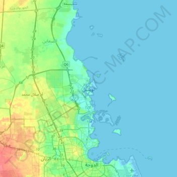
Nombre: Mapa topográfico Lusail, altitud, relieve.
Lugar: Lusail, Al-Daayen, Qatar (25.26289 51.35972 25.58289 51.67972)
Altitud media: 9 m
Altitud mínima: -4 m
Altitud máxima: 49 m
Groundwater quality in the area is poor. On the city's border with the Persian Gulf, the groundwater elevation is 1 meter above sea level and flows east-to-west. Salinity levels are highest on the eastern side, at 40 ppt, compared to a low of 18 ppt in the western section; these levels are too high for consumption or use in agriculture. Because of the groundwater's high salinity, only salt- and drought-tolerant plants grow in this area. A geographic survey found 25 species of plants within city limits; all of which are found abundantly elsewhere on the peninsula.