
Mapa topográfico Wards Island
Mapa interactivo
Haga clic en el mapa para ver la altitud.
Acerca de este mapa
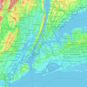
Nombre: Mapa topográfico Wards Island, altitud, relieve.
Altitud media: 35 m
Altitud mínima: -6 m
Altitud máxima: 350 m
Otros mapas topográficos
Haga clic en un mapa para ver su topografía, su altitud y su relieve.
Liberty Island
United States of America > New York > New York
Liberty Island, Manhattan Community Board 1, Manhattan, New York County, New York, Stone Street Historic District, New York, United States of America
Altitud media: 0 m
Todt Hill
United States of America > New York > New York
Todt Hill, Staten Island, New York, Richmond County, New York, 10304, United States of America
Altitud media: 75 m
Manhattan
United States of America > New York > New York
Chinatown, Manhattan Community Board 2, Manhattan, New York County, New York, United States of America
Altitud media: 12 m