
Haz una donación
Mapa topográfico Anticosti Island
Haga clic en el mapa para ver la altitud.
Haz una donación
Anticosti Island
Topographically, Anticosti Island can be divided into three distinct regions: two lowland areas, rarely exceeding 150 metres (490 ft) in elevation, in the eastern and western thirds of the island linked along the coast; and a central highland forming a plateau that rises to just over 300 m (980 ft). This plateau is an unidirectional structure slightly tilted to the south, and is characterized by rolling cuestas. The rocks exposed on the island form a continuous sedimentary stratum more than 2,000 m (6,600 ft) thick. These are the most complete strata in eastern North America of the Ordovician and Silurian periods.
Haz una donación
Acerca de este mapa
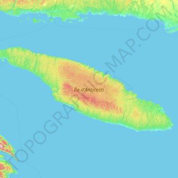
Nombre: Mapa topográfico Anticosti Island, altitud, relieve.
Lugar: Anticosti Island, Quebec, Canada (49.06204 -64.52403 49.95210 -61.66926)
Altitud media: 30 m
Altitud mínima: -2 m
Altitud máxima: 524 m
Haz una donación
Otros mapas topográficos
Haga clic en un mapa para ver su topografía, su altitud y su relieve.
Quebec
Canada > Quebec > Urban agglomeration of Québec
Quebec City was built on the north bank of the Saint Lawrence River, where it narrows and meets the mouth of the Saint-Charles River. Old Quebec is located on top and at the foot of Cap-Diamant, which is on the eastern edge of a plateau called the promontory of Quebec (Quebec hill). Because of this topographic…
Altitud media: 100 m
Haz una donación
Mount Royal
Canada > Quebec > Urban agglomeration of Montreal > Montreal
The hill is part of the Monteregian Hills situated between the Laurentians and the Appalachian Mountains. It gave its Latin name, Mons Regius, to the Monteregian chain. The hill consists of three peaks: Colline de la Croix (or Mont Royal proper) at 233 m (764 ft), Colline d'Outremont (or Mount Murray, in the…
Altitud media: 111 m
Haz una donación
Haz una donación
Haz una donación
Haz una donación
Mont Gosford
Canada > Quebec > Le Granit > Saint-Augustin-de-Woburn
Since 1978, Mount Gosford is included in "ZEC Louise-Gosford", a controlled harvesting zone open to the public. Recently, the areas at more than 700 metres of altitude were designated Important Bird Areas due to the presence Bicknell's thrushes, an endemic species living in mountain peaks of northeast North…
Altitud media: 933 m
Haz una donación
Haz una donación
Haz una donación
Haz una donación
Haz una donación
Haz una donación
Haz una donación
Haz una donación
Haz una donación
Haz una donación
Haz una donación
Haz una donación
Haz una donación
Haz una donación
Haz una donación
Scouts Canada - Lake Lovering Scouts Reserve
Canada > Quebec > Memphrémagog > Magog
Altitud media: 260 m
Haz una donación
Madeleine-Centre
Canada > Quebec > La Haute-Gaspésie > Sainte-Madeleine-de-la-Rivière-Madeleine
Altitud media: 72 m
Haz una donación
Haz una donación
Rivière-la-Madeleine
Canada > Quebec > La Haute-Gaspésie > Sainte-Madeleine-de-la-Rivière-Madeleine
Altitud media: 46 m
Gault Nature Reserve
Canada > Quebec > La Vallée-du-Richelieu > Mont-Saint-Hilaire
Altitud media: 189 m
Haz una donación
Haz una donación