
Mapa topográfico Pourchery
Mapa interactivo
Haga clic en el mapa para ver la altitud.
Acerca de este mapa
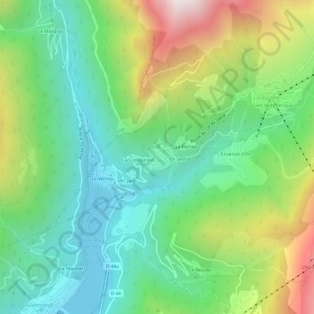
Nombre: Mapa topográfico Pourchery, altitud, relieve.
Altitud media: 1.228 m
Altitud mínima: 749 m
Altitud máxima: 2.181 m
Otros mapas topográficos
Haga clic en un mapa para ver su topografía, su altitud y su relieve.
Grand Vaujany
France > Auvergne-Rhône-Alpes > Isère > Vaujany
Grand Vaujany, Vaujany, Grenoble, Isère, Auvergne-Rhône-Alpes, France métropolitaine, 38114, France
Altitud media: 1.572 m
La Condamine
France > Auvergne-Rhône-Alpes > Isère > Vaujany
La Condamine, Vaujany, Grenoble, Isère, Auvergne-Rhône-Alpes, France métropolitaine, 38114, France
Altitud media: 1.217 m
Petit Vaujany
France > Auvergne-Rhône-Alpes > Isère > Vaujany > Petit Vaujany
Petit Vaujany, Vaujany, Grenoble, Isère, Auvergne-Rhône-Alpes, France métropolitaine, 38114, France
Altitud media: 1.489 m
La Vilette
France > Auvergne-Rhône-Alpes > Isère > Vaujany
La Vilette, Vaujany, Grenoble, Isère, Auvergne-Rhône-Alpes, France métropolitaine, 38114, France
Altitud media: 1.753 m