
Haz una donación
Mapa topográfico Preiss Heights
Haga clic en el mapa para ver la altitud.
Haz una donación
Acerca de este mapa
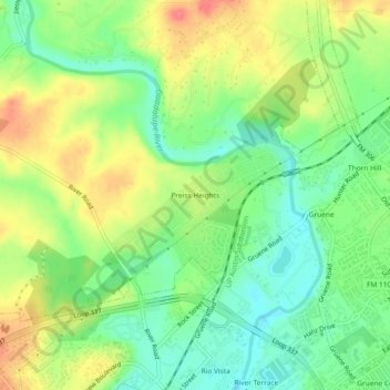
Nombre: Mapa topográfico Preiss Heights, altitud, relieve.
Lugar: Preiss Heights, Comal County, Texas, 78135, United States (29.72050 -98.13918 29.76050 -98.09918)
Altitud media: 214 m
Altitud mínima: 185 m
Altitud máxima: 251 m
Haz una donación
Otros mapas topográficos
Haga clic en un mapa para ver su topografía, su altitud y su relieve.
New Braunfels
United States > Texas > Comal County
New Braunfels occupies a transitional Hill Country setting on the Balcones Escarpment, where the higher, more dissected limestone uplands of the Edwards Plateau give way southeastward toward lower prairie terrain. The city’s relief is organized around the Guadalupe River valley and the short spring-fed Comal…
Altitud media: 228 m
Haz una donación
New Braunfels
United States > Texas > Comal County
New Braunfels occupies a transitional Hill Country setting on the Balcones Escarpment, where the higher, more dissected limestone uplands of the Edwards Plateau give way southeastward toward lower prairie terrain. The city’s relief is organized around the Guadalupe River valley and the short spring-fed Comal…
Altitud media: 228 m
Comal River
United States > Texas > Comal County > New Braunfels > Landa Park Estates
Altitud media: 206 m
Haz una donación