
Mapa topográfico Ojén
Mapa interactivo
Haga clic en el mapa para ver la altitud.
Acerca de este mapa
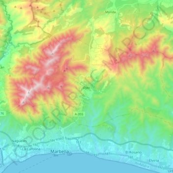
Nombre: Mapa topográfico Ojén, altitud, relieve.
Lugar: Ojén, Sierra de las Nieves, Malaga, Andalusia, 29610, Spain (36.52108 -4.92218 36.60949 -4.73540)
Altitud media: 404 m
Altitud mínima: -1 m
Altitud máxima: 1.254 m
The town is situated beside the Almadán stream above the valley of the River Real at an altitude of approximately 200 metres, hemmed in by the Sierra Blanca and the Sierra Alpujata. These may provide a clue to the Moors' determination to stay in spite of their apparent antipathy, for both ranges of mountains have long been known as rich sources of talc, nickel, iron and lead. This mineral wealth put the area in the forefront of the Spanish industrial revolution of the 19th century.
Otros mapas topográficos
Haga clic en un mapa para ver su topografía, su altitud y su relieve.
Casarabonela
Spain > Andalusia > Sierra de las Nieves
Casarabonela, Sierra de las Nieves, Malaga, Andalusia, Spain
Altitud media: 559 m