
Mapa topográfico Graham County
Mapa interactivo
Haga clic en el mapa para ver la altitud.
Acerca de este mapa
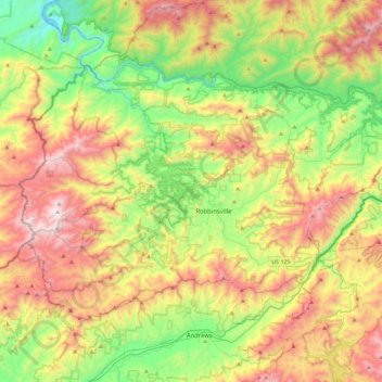
Nombre: Mapa topográfico Graham County, altitud, relieve.
Lugar: Graham County, North Carolina, United States of America (35.21693 -84.03808 35.46652 -83.58240)
Altitud media: 850 m
Altitud mínima: 265 m
Altitud máxima: 1.686 m
According to the U.S. Census Bureau, the county has a total area of 302 square miles (780 km2), of which 292 square miles (760 km2) is land and 9.6 square miles (25 km2) (3.2%) is water. The terrain of the county is mountainous, with elevations ranging from 1,177 feet (359 m) to 5,560 feet (1,690 m). Two-thirds of the county is the Nantahala National Forest. The soil of the valleys is fertile.
Otros mapas topográficos
Haga clic en un mapa para ver su topografía, su altitud y su relieve.
Avon
United States of America > North Carolina > Avon
Avon, Dare County, North Carolina, 27915, United States of America
Altitud media: 0 m
Buncombe County
United States of America > North Carolina
Buncombe County, North Carolina, United States of America
Altitud media: 839 m
Rockingham County
United States of America > North Carolina
Rockingham County, North Carolina, United States of America
Altitud media: 222 m
Lincoln County
United States of America > North Carolina
Lincoln County, North Carolina, United States of America
Altitud media: 266 m
Jones County
United States of America > North Carolina
Jones County, North Carolina, United States of America
Altitud media: 13 m
Pamlico County
United States of America > North Carolina
Pamlico County, North Carolina, United States of America
Altitud media: 5 m