
Mapa topográfico Cody
Mapa interactivo
Haga clic en el mapa para ver la altitud.
Acerca de este mapa
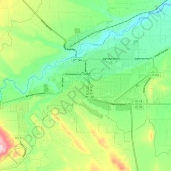
Nombre: Mapa topográfico Cody, altitud, relieve.
Lugar: Cody, Park County, Wyoming, United States (44.48981 -109.12048 44.55131 -109.00576)
Altitud media: 1.557 m
Altitud mínima: 1.436 m
Altitud máxima: 1.798 m
Cody's elevation is approximately 5016 ft (1,500 m) above sea level. The main part of the city is split across three levels, separated by about 60 feet (18 m).