
Gracias por apoyar a este sitio ❤️
Haz una donación
Haz una donación
Mapa topográfico Lancaster
Haga clic en el mapa para ver la altitud.
Gracias por apoyar a este sitio ❤️
Haz una donación
Haz una donación
Lancaster
Lancaster is located at 42°50′55″N 90°42′38″W / 42.848505°N 90.710430°W / 42.848505; -90.710430 (42.848505, −90.710430). Lancaster is located in the unglaciated "Driftless Area" of southwest Wisconsin whose topography is strikingly different from that of the rest of the state.
Gracias por apoyar a este sitio ❤️
Haz una donación
Haz una donación
Acerca de este mapa
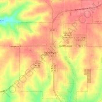
Nombre: Mapa topográfico Lancaster, altitud, relieve.
Lugar: Lancaster, Grant County, Wisconsin, 53813, United States (42.83186 -90.72446 42.86471 -90.68463)
Altitud media: 326 m
Altitud mínima: 274 m
Altitud máxima: 349 m
Gracias por apoyar a este sitio ❤️
Haz una donación
Haz una donación
Otros mapas topográficos
Haga clic en un mapa para ver su topografía, su altitud y su relieve.