
Mapa topográfico Boundary Peak
Mapa interactivo
Haga clic en el mapa para ver la altitud.
Acerca de este mapa
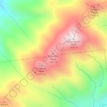
Nombre: Mapa topográfico Boundary Peak, altitud, relieve.
Lugar: Boundary Peak, Essex County, New York, USA (44.13980 -73.99390 44.13990 -73.99380)
Altitud media: 1.175 m
Altitud mínima: 772 m
Altitud máxima: 1.548 m
Otros mapas topográficos
Haga clic en un mapa para ver su topografía, su altitud y su relieve.
Avalanche Lake
Avalanche Lake, Avalanche Pass Trail, Essex County, New York, USA
Altitud media: 1.066 m
Spike Island
Spike Island, Rye, Westchester County, New York, 10587, USA
Altitud media: 50 m
Joshua
USA > New York > Town of Onondaga > Joshua
Joshua, Town of Onondaga, Onondaga County, New York, 13110, USA
Altitud media: 332 m
Atlantic Basin
Atlantic Basin, New York County, New York, 11231, USA
Altitud media: 4 m
Livingston Island
Livingston Island, Town of Philipstown, Putnam County, New York, 10922, USA
Altitud media: 156 m
Big Bear Mountain
Big Bear Mountain, Town of Johnsburg, Warren County, New York, USA
Altitud media: 616 m
Sawtooth Mountains
Sawtooth Mountains, Franklin County, New York, USA
Altitud media: 927 m
Flat Top Mountain
Flat Top Mountain, Franklin County, New York, USA
Altitud media: 568 m
Mount Warren
Mount Warren, Town of Bovina, Delaware County, New York, USA
Altitud media: 677 m
Roosevelt Island
USA > New York > New York City
Roosevelt Island, Manhattan Community Board 8, New York County, New York City, New York, 10044, USA
Altitud media: 13 m