
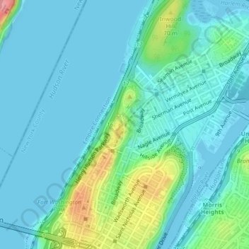
Mapa topográfico Fort Tryon Park
Mapa interactivo
Haga clic en el mapa para ver la altitud.
Acerca de este mapa
Nombre: Mapa topográfico Fort Tryon Park, altitud, relieve.
Altitud media: 20 m
Altitud mínima: -2 m
Altitud máxima: 106 m
In preparation for converting the land into a city park, Rockefeller hired the Olmsted Brothers firm, particularly Frederick Law Olmsted Jr., son of the designer of Central Park. Olmsted's design capitalized on the topography to reveal sweeping vistas of the Hudson River and the Palisades. Olmsted Jr. was guided by the four principles of park design that his father had established in creating Central Park: the beautiful, as seen in small open lawns; the picturesque, as shown in wooded slopes; the sublime, represented in the vistas of the Hudson River; and the gardenesque, exemplified by the park's Heather and Alpine Gardens. Olmsted Jr. had a preliminary report in 1927 and conducted a more exhaustive study in 1928-1930. In addition, James W. Dawson was hired to create a park-planting plan.
Otros mapas topográficos
Haga clic en un mapa para ver su topografía, su altitud y su relieve.
Manhattan
United States > New York > New York County > New York
Manhattan, New York County, New York, United States
Altitud media: 16 m
Central Park
United States > New York > New York County > New York
Central Park, New York County, New York, United States
Altitud media: 26 m
Roosevelt Island
United States > New York > New York County > New York
Roosevelt Island, Manhattan, New York County, New York, 10044, United States
Altitud media: 13 m
Battery Park
United States > New York > New York County > New York
Battery Park, Manhattan Community Board 1, Manhattan, New York County, New York, 10004, United States
Altitud media: 3 m
Sara D. Roosevelt Park
United States > New York > New York County > New York
Sara D. Roosevelt Park, Lower East Side, Manhattan, New York County, New York, United States
Altitud media: 14 m
Brooklyn Bridge Park
United States > New York > New York County > New York
Brooklyn Bridge Park, Kings County, New York County, New York, 11201, United States
Altitud media: 9 m
Paley Park
United States > New York > New York County > New York
Paley Park, Midtown East, Manhattan, New York County, New York, 10022, United States
Altitud media: 24 m
Liberty Island
United States > New York > New York County > New York
Liberty Island, Manhattan Community Board 1, Manhattan, New York County, New York, Hudson County, New York, United States
Altitud media: 0 m
Morningside Park
United States > New York > New York County > New York
Morningside Park, Morningside Heights, Manhattan, New York County, New York, United States
Altitud media: 20 m
Bennett Park
United States > New York > New York County > New York
Bennett Park, Hudson Heights, Manhattan, New York County, New York, United States
Altitud media: 24 m
Hunter’s Point South Waterfront Park
United States > New York > New York County > New York
Hunter’s Point South Waterfront Park, Manhattan Community Board 6, Manhattan, New York County, New York, United States
Altitud media: 5 m
Teardrop Park
United States > New York > New York County > New York
Teardrop Park, Manhattan Community Board 1, Manhattan, New York County, New York, United States
Altitud media: 6 m
Governors Island
United States > New York > New York County > New York
Governors Island, Manhattan, New York County, New York, United States
Altitud media: 1 m
Sherman Square
United States > New York > New York County > New York
Sherman Square, Manhattan Community Board 7, Manhattan, New York County, New York, United States
Altitud media: 22 m
Highbridge Park
United States > New York > New York County > New York
Highbridge Park, Manhattan, New York County, New York, United States
Altitud media: 30 m