
Haz una donación
Mapa topográfico Barrie
Haga clic en el mapa para ver la altitud.
Haz una donación
Barrie
On September 7, 1977, a private aircraft, flown by "Army" Hollingsworth, dropped altitude to 500 feet (152 m) in dense fog and struck CKVR's 1,000-foot (305 m) transmitter tower, killing all five people aboard the plane and destroying the tower and antenna. The station's 225-foot (69 m) auxiliary tower was also destroyed with damage to the main studio building. CKVR returned to the air on September 19 at a reduced power of 40,000 watts until a new 1,000-foot (305 m) tower was built in 1978.
Haz una donación
Acerca de este mapa
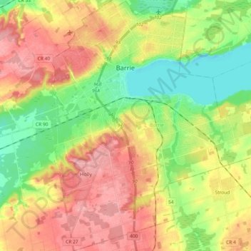
Nombre: Mapa topográfico Barrie, altitud, relieve.
Lugar: Barrie, Central Ontario, Ontario, Canada (44.29375 -79.74565 44.42459 -79.58590)
Altitud media: 265 m
Altitud mínima: 212 m
Altitud máxima: 321 m
Haz una donación
Otros mapas topográficos
Haga clic en un mapa para ver su topografía, su altitud y su relieve.
Upsala
Canada > Ontario > Thunder Bay District > Unorganized Thunder Bay District
Altitud media: 487 m
Haz una donación
Haz una donación
Avonmore
Canada > Ontario > Stormont, Dundas and Glengarry Counties > North Stormont
Altitud media: 95 m
Haz una donación
London
London has a humid continental climate (Köppen Dfb), though due to its downwind location relative to Lake Huron and elevation changes across the city, it is virtually on the Dfa/Dfb (hot summer) boundary favouring the former climate zone to the southwest of the confluence of the South and North Thames Rivers,…
Altitud media: 269 m
Haz una donación
Tipperary Island
Canada > Ontario > Leeds and Grenville Counties > Leeds and the Thousand Islands
Altitud media: 103 m
Haz una donación
Haz una donación
Haz una donación