
Gracias por apoyar a este sitio ❤️
Haz una donación
Haz una donación
Mapa topográfico Valencia
Haga clic en el mapa para ver la altitud.
Gracias por apoyar a este sitio ❤️
Haz una donación
Haz una donación
Valencia
Valencia occupies an area of 14,749 hectares (36,450 acres), 35% of which are classified as plains. The town is 65% mountainous, with elevation averaging from 200 to 500 metres (660 to 1,640 ft) above sea level, with the top of Mount Talinis at an elevation of 1,903 metres (6,243 ft) along the municipal southern boundary. The climate in the municipality is relatively cool, especially at higher elevations.
Gracias por apoyar a este sitio ❤️
Haz una donación
Haz una donación
Acerca de este mapa
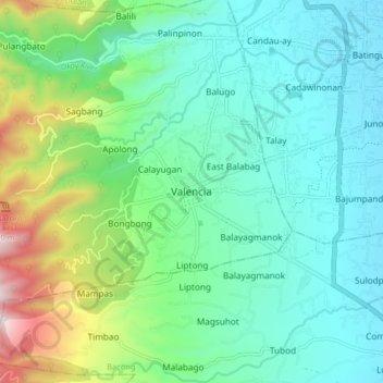
Nombre: Mapa topográfico Valencia, altitud, relieve.
Lugar: Valencia, Negros Oriental, Central Visayas, 6215, Philippines (9.24178 123.20468 9.32178 123.28468)
Altitud media: 250 m
Altitud mínima: 24 m
Altitud máxima: 966 m
Gracias por apoyar a este sitio ❤️
Haz una donación
Haz una donación
Otros mapas topográficos
Haga clic en un mapa para ver su topografía, su altitud y su relieve.