
Mapa topográfico Garfield Heights
Mapa interactivo
Haga clic en el mapa para ver la altitud.
Acerca de este mapa
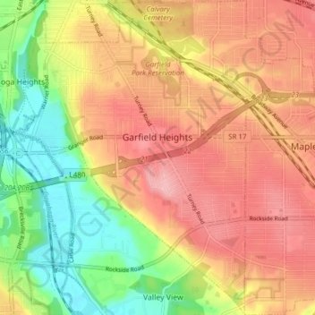
Nombre: Mapa topográfico Garfield Heights, altitud, relieve.
Altitud media: 251 m
Altitud mínima: 178 m
Altitud máxima: 308 m
According to the United States Census Bureau, the city has a total area of 7.29 square miles (18.88 km2), of which 7.23 square miles (18.73 km2) is land and 0.06 square miles (0.16 km2) is water. The elevation of Garfield Heights is 831 feet (253 m) above sea level where it borders Cleveland, and its highest elevation is 972 feet (296 m) above sea level at the Garfield Heights Justice Center.