
Mapa topográfico Durham
Mapa interactivo
Haga clic en el mapa para ver la altitud.
Acerca de este mapa
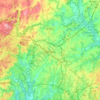
Nombre: Mapa topográfico Durham, altitud, relieve.
Lugar: Durham, Durham County, North Carolina, United States (35.86635 -79.00750 36.13701 -78.75959)
Altitud media: 117 m
Altitud mínima: 61 m
Altitud máxima: 238 m
Durham is located in the east-central part of the Piedmont region at 35°59′19″N 78°54′26″W / 35.98861°N 78.90722°W / 35.98861; -78.90722 (35.988644, −78.907167).[45] Like much of the region, its topography is generally flat with some rolling hills.