
Mapa topográfico Branderschrofen
Mapa interactivo
Haga clic en el mapa para ver la altitud.
Acerca de este mapa
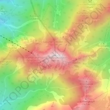
Nombre: Mapa topográfico Branderschrofen, altitud, relieve.
Altitud media: 1.423 m
Altitud mínima: 966 m
Altitud máxima: 1.860 m
Otros mapas topográficos
Haga clic en un mapa para ver su topografía, su altitud y su relieve.
Bleckenau
Deutschland > Bayern > Landkreis Ostallgäu > Schwangau
Bleckenau, Schwangau, Landkreis Ostallgäu, Bayern, Deutschland
Altitud media: 1.435 m
Horn
Deutschland > Bayern > Landkreis Ostallgäu > Schwangau
Horn, Schwangau, Landkreis Ostallgäu, Bayern, 87645, Deutschland
Altitud media: 812 m