
Mapa topográfico Saint Louis County
Mapa interactivo
Haga clic en el mapa para ver la altitud.
Acerca de este mapa
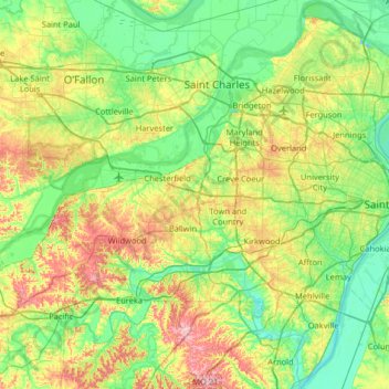
Nombre: Mapa topográfico Saint Louis County, altitud, relieve.
Lugar: Saint Louis County, Missouri, United States of America (38.38641 -90.73659 38.89216 -90.11771)
Altitud media: 166 m
Altitud mínima: 113 m
Altitud máxima: 290 m
The foothills of the Ozark Mountains begin in southwestern St. Louis County, with most of the rest of the county being a fairly level plateau. This western part of the county is the least developed, due to rugged topography. Bluffs along the Mississippi in the south of the county rise about 200–300 feet above the river. A major floodplain area is the Chesterfield Valley, in the western part of the county, along the Missouri River. It was formerly called "Gumbo Flats" after its rich, dark soil; it was submerged by at least ten feet of water during the Great Flood of 1993. The Corps of Engineers constructed a higher levee, and the county has permitted construction in the floodplain.
Otros mapas topográficos
Haga clic en un mapa para ver su topografía, su altitud y su relieve.
Buchanan County
United States of America > Missouri
Buchanan County, Missouri, United States of America
Altitud media: 288 m
Scotsdale
United States of America > Missouri > Scotsdale
Scotsdale, Jefferson County, Missouri, United States of America
Altitud media: 196 m
Cole County
United States of America > Missouri
Cole County, Missouri, United States of America
Altitud media: 219 m
Platte County
United States of America > Missouri
Platte County, Missouri, United States of America
Altitud media: 276 m
Downtown
United States of America > Missouri > Saint Louis
Downtown, Saint Louis, City of Saint Louis, Missouri, United States of America
Altitud media: 138 m