
Mapa topográfico Bridge of Allan
Mapa interactivo
Haga clic en el mapa para ver la altitud.
Acerca de este mapa
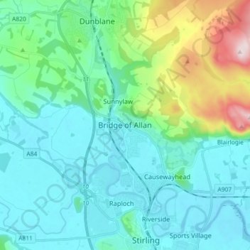
Nombre: Mapa topográfico Bridge of Allan, altitud, relieve.
Lugar: Bridge of Allan, Stirling, Scotland, FK9 4HW, United Kingdom (56.11504 -3.98807 56.19504 -3.90807)
Altitud media: 80 m
Altitud mínima: -1 m
Altitud máxima: 416 m
Otros mapas topográficos
Haga clic en un mapa para ver su topografía, su altitud y su relieve.
Loch Lomond and The Trossachs National Park
United Kingdom > Scotland > Stirling
The park straddles the Highland Boundary Fault, which divides it into two distinct regions - lowland and highland - that differ in underlying geology, soil types and topography. The change in rock type can most clearly be seen at Loch Lomond itself, as the fault runs across the islands of Inchmurrin, Creinch,…
Altitud media: 291 m