
Mapa topográfico Columbia River
Mapa interactivo
Haga clic en el mapa para ver la altitud.
Acerca de este mapa
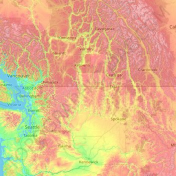
Nombre: Mapa topográfico Columbia River, altitud, relieve.
Altitud media: 1.102 m
Altitud mínima: -2 m
Altitud máxima: 4.151 m
The Columbia's heavy flow and large elevation drop over a short distance, 2.16 feet per mile (40.9 cm/km), give it tremendous capacity for hydroelectricity generation. In comparison, the Mississippi drops less than 0.65 feet per mile (12.3 cm/km). The Columbia alone possesses one-third of the United States's hydroelectric potential. In 2012, the river and its tributaries accounted for 29 GW of hydroelectric generating capacity, contributing 44 percent of the total hydroelectric generation in the nation.
Otros mapas topográficos
Haga clic en un mapa para ver su topografía, su altitud y su relieve.
Ashnola River
United States of America > Washington > Okanogan County
Ashnola River, Okanogan County, Washington, United States of America
Altitud media: 2.019 m
Silver Star Mountain
United States of America > Washington > Okanogan County
Silver Star Mountain, Okanogan County, Washington, United States of America
Altitud media: 2.161 m