
Mapa topográfico Salt Lick
Mapa interactivo
Haga clic en el mapa para ver la altitud.
Acerca de este mapa
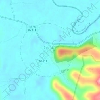
Nombre: Mapa topográfico Salt Lick, altitud, relieve.
Lugar: Salt Lick, Bath County, Kentucky, United States (38.11210 -83.62489 38.12657 -83.60631)
Altitud media: 217 m
Altitud mínima: 195 m
Altitud máxima: 316 m
Otros mapas topográficos
Haga clic en un mapa para ver su topografía, su altitud y su relieve.
Sharpsburg
United States > Kentucky > Bath County
Sharpsburg, Bath County, Kentucky, United States
Altitud media: 297 m
Olympia
United States > Kentucky > Bath County
Olympia, Bath County, Kentucky, 40358, United States
Altitud media: 248 m
Owingsville
United States > Kentucky > Bath County
Owingsville, Bath County, Kentucky, 40360, United States
Altitud media: 262 m
Pioneer Weapons Wildlife Management Area
United States > Kentucky > Bath County
Pioneer Weapons Wildlife Management Area, Bath County, Kentucky, United States
Altitud media: 323 m