
Mapa topográfico Maasmechelen
Mapa interactivo
Haga clic en el mapa para ver la altitud.
Acerca de este mapa
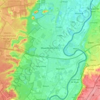
Nombre: Mapa topográfico Maasmechelen, altitud, relieve.
Lugar: Maasmechelen, Tongeren, Limburg, Belgium (50.91037 5.59532 51.01227 5.76767)
Altitud media: 57 m
Altitud mínima: 28 m
Altitud máxima: 119 m
The plateau of Campine was built up during the ice age with deposits of sand and other material that the Meuse river had eroded in the upstream Ardennes region. The higher elevation and the proximity of fertile river clay made this location an attractive one for the prehistoric tribes who established themselves here in the 2nd millennium BC and for the Celtic peoples who moved in the area in the 1st millennium BC.
Otros mapas topográficos
Haga clic en un mapa para ver su topografía, su altitud y su relieve.
Waltwilder
Belgium > Limburg > Tongeren > Bilzen
Waltwilder, Bilzen, Tongeren, Limburg, Flanders, Belgium
Altitud media: 75 m
Veurs
Belgium > Limburg > Tongeren > Sint-Martens-Voeren
Veurs, Sint-Martens-Voeren, Voeren, Tongeren, Limburg, Flanders, 3790, Belgium
Altitud media: 213 m
Eigenbilzen
Belgium > Limburg > Tongeren > Bilzen > Eigenbilzen
Eigenbilzen, Bilzen, Tongeren, Limburg, Flanders, Belgium
Altitud media: 75 m
Rullekoven
Belgium > Limburg > Tongeren > Borgloon > Kerniel > Rullekoven
Rullekoven, Kerniel, Borgloon, Tongeren, Limburg, Flanders, 3840, Belgium
Altitud media: 84 m