
Mapa topográfico The Woodlands
Mapa interactivo
Haga clic en el mapa para ver la altitud.
Acerca de este mapa
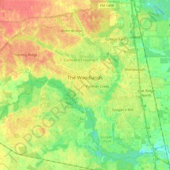
Nombre: Mapa topográfico The Woodlands, altitud, relieve.
Lugar: The Woodlands, Montgomery County, Texas, United States (30.10304 -95.60120 30.23057 -95.43430)
Altitud media: 47 m
Altitud mínima: 23 m
Altitud máxima: 72 m
The Woodlands is in a heavily forested area, and much of the community has retained trees for shade and decoration. The terrain is essentially flat, with the exception of topographic variations ranging from 125 to 175 feet above sea level between Spring Creek and Flintridge Drive.