
Mapa topográfico Manchester
Mapa interactivo
Haga clic en el mapa para ver la altitud.
Acerca de este mapa
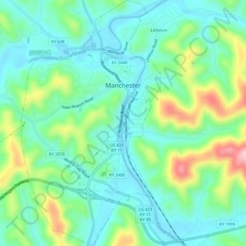
Nombre: Mapa topográfico Manchester, altitud, relieve.
Lugar: Manchester, Clay County, Kentucky, 40962, United States (37.12780 -83.78244 37.16738 -83.75430)
Altitud media: 315 m
Altitud mínima: 253 m
Altitud máxima: 477 m
Otros mapas topográficos
Haga clic en un mapa para ver su topografía, su altitud y su relieve.
Oneida
United States > Kentucky > Clay County
Oneida, Clay County, Kentucky, United States
Altitud media: 297 m
Littleton
United States > Kentucky > Clay County
Littleton, Clay County, Kentucky, 40962, United States
Altitud media: 315 m
Sextons Creek
United States > Kentucky > Clay County
Sextons Creek, Clay County, Kentucky, 40983, United States
Altitud media: 311 m
Big Creek
United States > Kentucky > Clay County
Big Creek, Clay County, Kentucky, 40914, United States
Altitud media: 354 m
Fall Rock
United States > Kentucky > Clay County
Fall Rock, Clay County, Kentucky, United States
Altitud media: 344 m
Vine
United States > Kentucky > Clay County
Vine, Clay County, Kentucky, United States
Altitud media: 335 m