
Mapa topográfico Château des Amerois
Mapa interactivo
Haga clic en el mapa para ver la altitud.
Acerca de este mapa
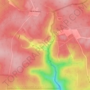
Nombre: Mapa topográfico Château des Amerois, altitud, relieve.
Altitud media: 401 m
Altitud mínima: 276 m
Altitud máxima: 441 m
Otros mapas topográficos
Haga clic en un mapa para ver su topografía, su altitud y su relieve.
Frahan
Belgique > Luxembourg > Neufchâteau > Bouillon
Frahan, Rochehaut, Bouillon, Neufchâteau, Luxembourg, Wallonie, 6838, Belgique
Altitud media: 291 m
Dohan
Belgique > Luxembourg > Neufchâteau > Bouillon
Dohan, Bouillon, Neufchâteau, Luxembourg, Wallonie, Belgique
Altitud media: 284 m
Botassart
Belgique > Luxembourg > Neufchâteau > Bouillon > Ucimont
Botassart, Ucimont, Bouillon, Neufchâteau, Luxembourg, Wallonie, 6833, Belgique
Altitud media: 319 m
Rochehaut
Belgique > Luxembourg > Neufchâteau > Bouillon
Rochehaut, Bouillon, Neufchâteau, Luxembourg, Wallonie, Belgique
Altitud media: 298 m
Corbion
Belgique > Luxembourg > Neufchâteau > Bouillon
Corbion, Bouillon, Neufchâteau, Luxembourg, Wallonie, 6838, Belgique
Altitud media: 344 m
Bouillon
Belgique > Luxembourg > Neufchâteau > Bouillon
Bouillon, Neufchâteau, Luxembourg, Wallonie, 6830, Belgique
Altitud media: 338 m
Sensenruth
Belgique > Luxembourg > Neufchâteau > Bouillon
Sensenruth, Bouillon, Neufchâteau, Luxembourg, Wallonie, 6832, Belgique
Altitud media: 359 m
Poupehan
Belgique > Luxembourg > Neufchâteau > Bouillon
Poupehan, Bouillon, Neufchâteau, Luxembourg, Wallonie, Belgique
Altitud media: 270 m
Cordemois
Belgique > Luxembourg > Neufchâteau > Bouillon
Cordemois, Bouillon, Neufchâteau, Luxembourg, Wallonie, 6830, Belgique
Altitud media: 312 m