
Haz una donación
Mapa topográfico Athabasca Falls
Haga clic en el mapa para ver la altitud.
Haz una donación
Acerca de este mapa
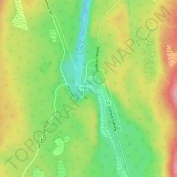
Nombre: Mapa topográfico Athabasca Falls, altitud, relieve.
Lugar: Athabasca Falls, Division No. 15, Alberta, Canada (52.66442 -117.88354 52.66452 -117.88344)
Altitud media: 1.211 m
Altitud mínima: 1.148 m
Altitud máxima: 1.281 m
Haz una donación
Otros mapas topográficos
Haga clic en un mapa para ver su topografía, su altitud y su relieve.
Columbia Icefield
Canada > Alberta > Division No. 15 > Area A (Kicking Horse/Kinbasket Lake)
Columbia Icefield has a alpine climate (Köppen: ETf), because the weather station is located at an altitude of 1,981.20 m (6,500 ft). The average annual temperature is −2.1 °C (28.2 °F). The month of July is the warmest with an average temperature of 9.1 °C (48.38 °F).
Altitud media: 2.484 m
Maligne Lake
Canada > Alberta > Division No. 15
Wildlife is surprisingly abundant along this high altitude oligotrophic lake. Grizzly bear, black bear, mule deer, caribou, wolves, moose, and mountain sheep are some of the larger mammals that frequent the lake area during the summer season. Bald eagles, golden eagles and osprey also frequent the area and…
Altitud media: 2.125 m
Bow Lake
Canada > Alberta > Division No. 15
Bow Lake is a small lake in western Alberta, Canada. It is located on the Bow River, in the Canadian Rockies, at an altitude of 1920 m.
Altitud media: 2.165 m
Haz una donación
Medicine Lake
Canada > Alberta > Division No. 15
Wildlife is surprisingly abundant along this high altitude lake. Grizzly bear, black bear, mule deer, caribou, wolves, moose and mountain sheep are some of the larger mammals that frequent the lake area during the summer season. Bald eagles, and osprey also frequent the area and live off the fish populations.
Altitud media: 1.681 m
Haz una donación