
Mapa topográfico Sandy Hook
Mapa interactivo
Haga clic en el mapa para ver la altitud.
Acerca de este mapa
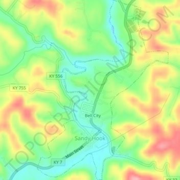
Nombre: Mapa topográfico Sandy Hook, altitud, relieve.
Lugar: Sandy Hook, Elliott County, Kentucky, United States (38.07983 -83.13701 38.10848 -83.11043)
Altitud media: 261 m
Altitud mínima: 207 m
Altitud máxima: 327 m
Otros mapas topográficos
Haga clic en un mapa para ver su topografía, su altitud y su relieve.
Culver
United States > Kentucky > Elliott County
Culver, Elliott County, Kentucky, United States
Altitud media: 271 m
Stark
United States > Kentucky > Elliott County
Stark, Elliott County, Kentucky, United States
Altitud media: 285 m
Ibex
United States > Kentucky > Elliott County
Ibex, Elliott County, Kentucky, United States
Altitud media: 249 m
Newfoundland
United States > Kentucky > Elliott County
Newfoundland, Elliott County, Kentucky, 41171, United States
Altitud media: 259 m
Isonville
United States > Kentucky > Elliott County
Isonville, Elliott County, Kentucky, 41149, United States
Altitud media: 275 m