
Mapa topográfico Town of Pawling
Mapa interactivo
Haga clic en el mapa para ver la altitud.
Acerca de este mapa
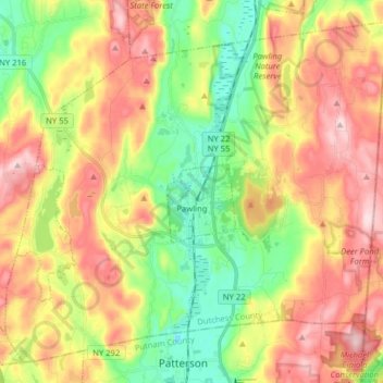
Nombre: Mapa topográfico Town of Pawling, altitud, relieve.
Lugar: Town of Pawling, Dutchess County, New York, United States (41.51400 -73.68023 41.61979 -73.52144)
Altitud media: 243 m
Altitud mínima: 104 m
Altitud máxima: 400 m
The eastern and western section of the towns are high and hilly, with the Great Swamp and Harlem Valley in the middle, where the village of Pawling is located. The highest elevation in town is Observatory Hill, at 1,332 feet (406 m) above sea level; the lowest is 420 feet (130 m), in the Great Swamp, along the southern boundary of the town.
Otros mapas topográficos
Haga clic en un mapa para ver su topografía, su altitud y su relieve.
Town of Amenia
United States > New York > Dutchess County
Town of Amenia, Dutchess County, New York, United States
Altitud media: 256 m
Town of Union Vale
United States > New York > Dutchess County
Town of Union Vale, Dutchess County, New York, 12585, United States
Altitud media: 227 m