
Gracias por apoyar a este sitio ❤️
Haz una donación
Haz una donación
Mapa topográfico Coal Mountain
Haga clic en el mapa para ver la altitud.
Gracias por apoyar a este sitio ❤️
Haz una donación
Haz una donación
Acerca de este mapa
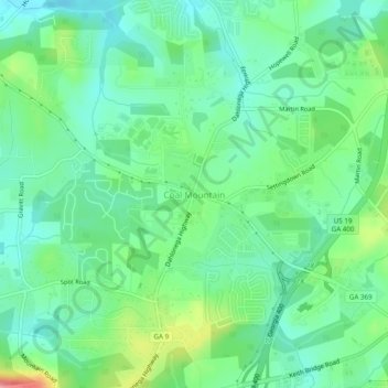
Nombre: Mapa topográfico Coal Mountain, altitud, relieve.
Lugar: Coal Mountain, Forsyth County, Georgia, 30028, United States (34.25149 -84.12075 34.29149 -84.08075)
Altitud media: 368 m
Altitud mínima: 336 m
Altitud máxima: 446 m
Gracias por apoyar a este sitio ❤️
Haz una donación
Haz una donación
Otros mapas topográficos
Haga clic en un mapa para ver su topografía, su altitud y su relieve.
Lake Lanier
United States > Georgia > Forsyth County > Cumming
According to the Army Corps of Engineers, the Dam has a current installed capacity of 126 megawatts and a hydraulic head of 136 feet. Other pertinent information on the reservoir, power plant, etc. can be found on the Mobile District Corps of Engineers web site.[12][13] Also, historic operational information…
Altitud media: 351 m
Gracias por apoyar a este sitio ❤️
Haz una donación
Haz una donación