
Mapa topográfico Boise
Mapa interactivo
Haga clic en el mapa para ver la altitud.
Boise
Boise (/ˈbɔɪsi/ (listen)) is the capital and most populous city of the U.S. state of Idaho, and is the county seat of Ada County. Located on the Boise River in southwestern Idaho, it is 41 miles (66 km) east of the Oregon border, and 110 miles (177 km) north of the Nevada border. The downtown area's elevation is 2,704 feet (824 m) above sea level. Its estimated population in 2018 was 228,790.
Acerca de este mapa
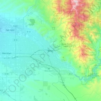
Nombre: Mapa topográfico Boise, altitud, relieve.
Lugar: Boise, Ada County, Idaho, 83702, United States of America (43.45662 -116.36089 43.77662 -116.04089)
Altitud media: 1.040 m
Altitud mínima: 762 m
Altitud máxima: 2.303 m