
Mapa topográfico Washoe County
Mapa interactivo
Haga clic en el mapa para ver la altitud.
Acerca de este mapa
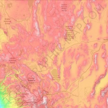
Nombre: Mapa topográfico Washoe County, altitud, relieve.
Lugar: Washoe County, Nevada, United States of America (39.16554 -120.00573 41.99764 -119.17271)
Altitud media: 1.528 m
Altitud mínima: 30 m
Altitud máxima: 3.161 m
According to the U.S. Census Bureau, the county has a total area of 6,542 square miles (16,940 km2), of which 6,302 square miles (16,320 km2) is land and 240 square miles (620 km2) (3.7%) is water. The highest point in Washoe County is Mount Rose at 10,785 ft (3,287 m), while the most topographically prominent peak is Virginia Peak.
Otros mapas topográficos
Haga clic en un mapa para ver su topografía, su altitud y su relieve.
Pershing County
United States of America > Nevada
Pershing County, Nevada, United States of America
Altitud media: 1.449 m
Elko County
United States of America > Nevada
Elko County, Nevada, United States of America
Altitud media: 1.838 m
Esmeralda County
United States of America > Nevada
Esmeralda County, Nevada, United States of America
Altitud media: 1.789 m