
Mapa topográfico Lamia
Mapa interactivo
Haga clic en el mapa para ver la altitud.
Acerca de este mapa
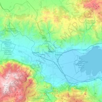
Nombre: Mapa topográfico Lamia, altitud, relieve.
Altitud media: 534 m
Altitud mínima: -4 m
Altitud máxima: 2.141 m
Otros mapas topográficos
Haga clic en un mapa para ver su topografía, su altitud y su relieve.
Komma
Greece > Thessaly and Central Greece > Phthiotis Regional Unit > Municipal Unit of Lamia
Komma, Municipal Unit of Lamia, Lamia Municipality, Phthiotis Regional Unit, Central Greece, Thessaly and Central Greece, 351 00, Greece
Altitud media: 12 m
Ypati
Greece > Thessaly and Central Greece > Phthiotis Regional Unit > Δημοτική Ενότητα Υπάτης
Ypati, Δημοτική Ενότητα Υπάτης, Lamia Municipality, Phthiotis Regional Unit, Central Greece, Thessaly and Central Greece, 350 16, Greece
Altitud media: 488 m
Varka
Greece > Thessaly and Central Greece > Phthiotis Regional Unit > Δημοτική Ενότητα Υπάτης > Loutra Ypatis
Varka, Κ. Λουτρών Υπάτης, Loutra Ypatis, Δημοτική Ενότητα Υπάτης, Lamia Municipality, Phthiotis Regional Unit, Central Greece, Thessaly and Central Greece, 350 16, Greece
Altitud media: 166 m
Φούρνοι
Greece > Thessaly and Central Greece > Phthiotis Regional Unit > Αχλάδι
Φούρνοι, Κ. Ραχών, Αχλάδι, Stylida Municipality, Phthiotis Regional Unit, Central Greece, Thessaly and Central Greece, 353 00, Greece
Altitud media: 22 m
Σκάρφεια
Greece > Thessaly and Central Greece > Phthiotis Regional Unit > Σκάρφεια
Σκάρφεια, Kamena Vourla Municipality, Phthiotis Regional Unit, Central Greece, Thessaly and Central Greece, 350 09, Greece
Altitud media: 20 m
Phthiotis Regional Unit
Greece > Thessaly and Central Greece > Phthiotis Regional Unit
Phthiotis Regional Unit, Central Greece, Thessaly and Central Greece, Greece
Altitud media: 480 m