
Mapa topográfico Busuanga
Mapa interactivo
Haga clic en el mapa para ver la altitud.
Acerca de este mapa
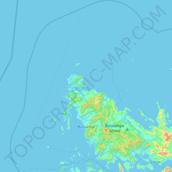
Nombre: Mapa topográfico Busuanga, altitud, relieve.
Lugar: Busuanga, Palawan, Mimaropa, 5317, Philippines (11.95889 119.64513 12.60692 120.15842)
Altitud media: 16 m
Altitud mínima: -1 m
Altitud máxima: 597 m
Elevation The municipality's western and central portions are predominantly rough and mountainous with rolling to hilly terrain. A part of this is the Chinabayan Mountain and Wayan Range that still support extensive parches of Molave forest and Cogon grassland (features which are dominant in the locale). Chinabayan, also called Sinibayan, is approximately near to Sinibayan River and the waterfalls found in Barangay New Busuanga. Chinabayan traverses along Barangay San Rafael and Barangay Sagrada where forest cover is much more extensive. Meanwhile, the hilly portions of the mountain range is covered by lowland beach and limestone forest while those that are confined to the sides of hills following the municipality's streams and river have thicker forest covers. The central hills have low elevation (less than 700 meters above sea level) while some have an elevation reaching more than 500 meters. Also, on the western portion are numerous islets while on the northern tip is the Calauit Island. The Salvacion Mountain Range located in Salvacion, the Sinabuyan Mountain Range between New Busuanga and Cheey, and the Naapac Mountain Range in San Rafael are among the major mountain ranges of the municipality.
Otros mapas topográficos
Haga clic en un mapa para ver su topografía, su altitud y su relieve.
Malcapuya Island
Philippines > Palawan > Culion
Malcapuya Island, Culion, Palawan, Mimaropa, Philippines
Altitud media: 2 m
Malaroroy Island
Philippines > Palawan > Coron > Bulog
Malaroroy Island, Bulog, Coron, Palawan, Mimaropa, Philippines
Altitud media: 2 m
Tagumpay
Philippines > Palawan > Coron
Tagumpay, Coron, Palawan, Mimaropa, 5316, Philippines
Altitud media: 30 m
Mount Mantalingajan
Mount Mantalingajan, Palawan, Mimaropa, Philippines
Altitud media: 1.647 m
Iloc Island
Philippines > Palawan > Linapacan
Iloc Island, Linapacan, Palawan, Mimaropa, Philippines
Altitud media: 23 m
Bebeladan
Philippines > Palawan > El Nido
Bebeladan, El Nido, Palawan, Mimaropa, Philippines
Altitud media: 47 m
Aberawan
Philippines > Palawan > El Nido
Aberawan, El Nido, Palawan, Mimaropa, Philippines
Altitud media: 37 m
Iguana Island
Philippines > Palawan > Culion
Iguana Island, Culion, Palawan, Mimaropa, 5315, Philippines
Altitud media: 5 m
Pamalican Island
Philippines > Palawan > Cuyo
Pamalican Island, Cuyo, Palawan, Mimaropa, 5318, Philippines
Altitud media: 1 m
Balabac Island
Balabac Island, Palawan, Mimaropa, Philippines
Altitud media: 20 m
Sofronio Española
Sofronio Española, Palawan, Mimaropa, 5305, Philippines
Altitud media: 30 m
Cagayancillo
Cagayancillo, Palawan, Mimaropa, 5321, Philippines
Altitud media: 0 m
Sitio Pandan
Philippines > Palawan > Coron
Sitio Pandan, Coron, Palawan, Mimaropa, 5316, Philippines
Altitud media: 45 m
Twin Lagoon
Philippines > Palawan > Coron
Twin Lagoon, Coron, Palawan, Mimaropa, 5316, Philippines
Altitud media: 106 m
Horse Island
Philippines > Palawan > Busuanga
Horse Island, Busuanga, Palawan, Mimaropa, 5317, Philippines
Altitud media: 1 m
Dicilingan Island
Philippines > Palawan > Busuanga
Dicilingan Island, Busuanga, Palawan, Mimaropa, 5317, Philippines
Altitud media: 1 m
Shimizu Island
Shimizu Island, Palawan, Mimaropa, Philippines
Altitud media: 18 m
Corong-Corong
Philippines > Palawan > Corong-Corong
Corong-Corong, Palawan, Mimaropa, 5313, Philippines
Altitud media: 57 m
Salvacion
Philippines > Palawan > Roxas > Salvacion
Salvacion, Roxas, Palawan, Mimaropa, Philippines
Altitud media: 12 m
Inabuyatan Island
Inabuyatan Island, Palawan, Mimaropa, Philippines
Altitud media: 3 m