
Haz una donación
Mapa topográfico Ellijay
Haga clic en el mapa para ver la altitud.
Haz una donación
Ellijay
Ellijay lies within the Humid subtropical climate zone along with the majority of the rest of the Southeastern United States. The highest elevations in the surrounding region reside in the oceanic climate. Ellijay enjoys cool winters and warm summers, but neither would be considered extreme due to its slightly higher elevation than other areas in the south. Winter snowfall is common, but generally on the lighter side. A few exceptions exist, one being the 1993 Storm of the Century, which dropped 17 inches of snow in Ellijay. Summers are warm, though mild for southern standards, with temperatures topping out in the mid 80s during the summer. Rain is evenly distributed throughout the year, averaging 57.97 inches per year, as reported from the nearest NOAA reporting station in Jasper, Georgia.
Haz una donación
Acerca de este mapa
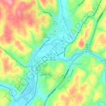
Nombre: Mapa topográfico Ellijay, altitud, relieve.
Lugar: Ellijay, Gilmer County, Georgia, 30540, United States (34.66807 -84.51152 34.70778 -84.46965)
Altitud media: 424 m
Altitud mínima: 373 m
Altitud máxima: 496 m
Haz una donación
Otros mapas topográficos
Haga clic en un mapa para ver su topografía, su altitud y su relieve.