
Mapa topográfico Ashland
Mapa interactivo
Haga clic en el mapa para ver la altitud.
Acerca de este mapa
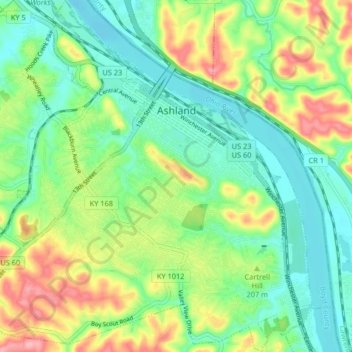
Nombre: Mapa topográfico Ashland, altitud, relieve.
Lugar: Ashland, Boyd County, Kentucky, United States (38.43440 -82.68193 38.49846 -82.60629)
Altitud media: 196 m
Altitud mínima: 155 m
Altitud máxima: 270 m
Otros mapas topográficos
Haga clic en un mapa para ver su topografía, su altitud y su relieve.
Normal
United States > Kentucky > Boyd County > Ashland > Normal
Normal, Ashland, Boyd County, Kentucky, 411011, United States
Altitud media: 187 m
Cliffside
United States > Kentucky > Boyd County > Ashland > Cliffside
Cliffside, Ashland, Boyd County, Kentucky, 411011, United States
Altitud media: 184 m