
Mapa topográfico Tazewell County
Mapa interactivo
Haga clic en el mapa para ver la altitud.
Acerca de este mapa
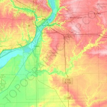
Nombre: Mapa topográfico Tazewell County, altitud, relieve.
Lugar: Tazewell County, Illinois, United States (40.31864 -89.92371 40.74827 -89.26375)
Altitud media: 190 m
Altitud mínima: 131 m
Altitud máxima: 259 m
Otros mapas topográficos
Haga clic en un mapa para ver su topografía, su altitud y su relieve.
Washington
United States > Illinois > Tazewell County
Washington, Tazewell County, Illinois, 61571, United States
Altitud media: 236 m
Deer Creek
United States > Illinois > Tazewell County
Deer Creek, Tazewell County, Illinois, United States
Altitud media: 227 m
Green Valley
United States > Illinois > Tazewell County
Green Valley, Tazewell County, Illinois, United States
Altitud media: 164 m
East Peoria
United States > Illinois > Tazewell County
East Peoria, Tazewell County, Illinois, 61611, United States
Altitud media: 176 m
Morton
United States > Illinois > Tazewell County
Morton, Tazewell County, Illinois, 61550, United States
Altitud media: 219 m