
Haz una donación
Mapa topográfico Batangas City
Haga clic en el mapa para ver la altitud.
Haz una donación
Batangas City
The city is the center of the radio listening market in Batangas, and is served by local radio stations, as well as some radio stations from Lipa and other parts of the Mega Manila area. The Roman Catholic Archdiocese of Lipa, through the Radyo Bayanihan System, hosts two local radio stations: ALFM 95.9 Radyo Totoo (DWAL), a religion, news, talk, and music-oriented station, and 99.1 Spirit FM (DWAM), a religion and music-oriented station. Other radio stations include 91.9 Air1 Radio Southern Tagalog (DWCH), an adult contemporary-oriented station, 99.9 GV FM (DZGV), a contemporary hit radio station, and 104.7 Brigada News FM (DWEY), an FM news radio station. Batangas State University hosts a college radio station, 107.3 BatStateU FM (DWPB-FM). Signals from other stations in Metro Manila are not clearly received because of the local topography.
Haz una donación
Acerca de este mapa
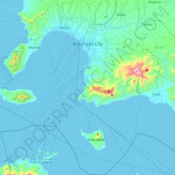
Nombre: Mapa topográfico Batangas City, altitud, relieve.
Lugar: Batangas City, Batangas, Calabarzon, 4200, Philippines (13.47385 120.98558 13.84918 121.19090)
Altitud media: 65 m
Altitud mínima: -1 m
Altitud máxima: 944 m
Haz una donación
Otros mapas topográficos
Haga clic en un mapa para ver su topografía, su altitud y su relieve.
Haz una donación
Mount Pico de Loro
Philippines > Batangas > Nasugbu
Mount Pico de Loro, also known as Mount Palay-Palay, is a dormant volcano located on the border of Cavite and Batangas, in the island of Luzon, Philippines. It is the highest mountain in the province of Cavite, with an elevation of 2,257 ft (688 m) above sea level and the highest peak of the Mounts…
Altitud media: 359 m
Haz una donación