
Mapa topográfico Almyros Municipality
Mapa interactivo
Haga clic en el mapa para ver la altitud.
Acerca de este mapa
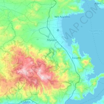
Nombre: Mapa topográfico Almyros Municipality, altitud, relieve.
Altitud media: 334 m
Altitud mínima: -2 m
Altitud máxima: 1.713 m
Otros mapas topográficos
Haga clic en un mapa para ver su topografía, su altitud y su relieve.
Ζαγορά
Greece > Thessaly and Central Greece > Regional Unit of Magnesia > Municipal Unit of Zagora
Ζαγορά, Municipal Unit of Zagora, Zagora - Mouresi Municipality, Regional Unit of Magnesia, Thessaly, Thessaly and Central Greece, 370 01, Greece
Altitud media: 523 m
Milina
Greece > Thessaly and Central Greece > Regional Unit of Magnesia > Sipias Municipal Unit
Milina, Sipias Municipal Unit, South Pilio Municipality, Regional Unit of Magnesia, Thessaly, Thessaly and Central Greece, 370 13, Greece
Altitud media: 81 m
Makrinitsa
Greece > Thessaly and Central Greece > Regional Unit of Magnesia > Volos Municipality
Makrinitsa, Volos Municipality, Regional Unit of Magnesia, Thessaly, Thessaly and Central Greece, 370 11, Greece
Altitud media: 663 m
Volos
Greece > Thessaly and Central Greece > Regional Unit of Magnesia > Volos
Volos, Volos Municipality, Regional Unit of Magnesia, Thessaly, Thessaly and Central Greece, 38333, Greece
Altitud media: 249 m
Volos Municipality
Greece > Thessaly and Central Greece > Regional Unit of Magnesia
Volos Municipality, Regional Unit of Magnesia, Thessaly, Thessaly and Central Greece, Greece
Altitud media: 228 m
Stefanovikio
Greece > Thessaly and Central Greece > Regional Unit of Magnesia
Stefanovikio, Rigas Feraios Municipality, Regional Unit of Magnesia, Thessaly, Thessaly and Central Greece, 375 00, Greece
Altitud media: 53 m
Agii Saranta
Greece > Thessaly and Central Greece > Regional Unit of Magnesia > Zagora > Agii Saranta
Agii Saranta, Zagora, Zagora - Mouresi Municipality, Regional Unit of Magnesia, Thessaly, Thessaly and Central Greece, 37001, Greece
Altitud media: 114 m
Horefto
Greece > Thessaly and Central Greece > Regional Unit of Magnesia
Horefto, Regional Unit of Magnesia, Thessaly, Thessaly and Central Greece, 370 01, Greece
Altitud media: 126 m