
Mapa topográfico Cave City
Mapa interactivo
Haga clic en el mapa para ver la altitud.
Acerca de este mapa
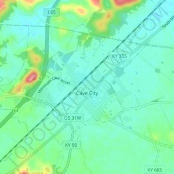
Nombre: Mapa topográfico Cave City, altitud, relieve.
Lugar: Cave City, Barren County, Kentucky, United States (37.12041 -85.99774 37.15645 -85.93421)
Altitud media: 207 m
Altitud mínima: 184 m
Altitud máxima: 290 m
Otros mapas topográficos
Haga clic en un mapa para ver su topografía, su altitud y su relieve.
Eighty Eight
United States > Kentucky > Barren County
Eighty Eight, Barren County, Kentucky, United States
Altitud media: 241 m
Etoile
United States > Kentucky > Barren County
Etoile, Barren County, Kentucky, 42131, United States
Altitud media: 246 m
Hiseville
United States > Kentucky > Barren County
Hiseville, Barren County, Kentucky, 42152, United States
Altitud media: 221 m
Rocky Hill
United States > Kentucky > Barren County
Rocky Hill, Barren County, Kentucky, United States
Altitud media: 206 m
Austin
United States > Kentucky > Barren County
Austin, Barren County, Kentucky, 42123, United States
Altitud media: 216 m
Park City
United States > Kentucky > Barren County
Park City, Barren County, Kentucky, United States
Altitud media: 201 m
Glasgow
United States > Kentucky > Barren County > Glasgow > Glasgow
Glasgow, Barren County, Kentucky, 42142, United States
Altitud media: 230 m
Lucas
United States > Kentucky > Barren County > Lucas
Lucas, Barren County, Kentucky, 42156, United States
Altitud media: 197 m
Glasgow
United States > Kentucky > Barren County
Glasgow, Barren County, Kentucky, United States
Altitud media: 230 m