
Gracias por apoyar a este sitio ❤️
Haz una donación
Haz una donación
Mapa topográfico Tingrith
Haga clic en el mapa para ver la altitud.
Gracias por apoyar a este sitio ❤️
Haz una donación
Haz una donación
Acerca de este mapa
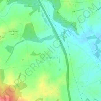
Nombre: Mapa topográfico Tingrith, altitud, relieve.
Lugar: Tingrith, Central Bedfordshire, England, United Kingdom (51.96963 -0.56520 51.99460 -0.52612)
Altitud media: 94 m
Altitud mínima: 72 m
Altitud máxima: 141 m
Gracias por apoyar a este sitio ❤️
Haz una donación
Haz una donación