
Mapa topográfico Al Rayyan
Mapa interactivo
Haga clic en el mapa para ver la altitud.
Acerca de este mapa
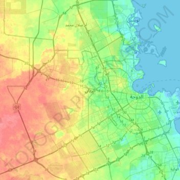
Nombre: Mapa topográfico Al Rayyan, altitud, relieve.
Lugar: Al Rayyan, Ar Rayyan, 945, Qatar (25.13662 51.27463 25.45662 51.59463)
Altitud media: 21 m
Altitud mínima: -3 m
Altitud máxima: 54 m
Similar to many other names given to Qatari settlements and municipalities, Al Rayyan Municipality was named after a geographic feature present in its namesake, the city of Al Rayyan. The city derives its name from the Arabic term "ray", which translates to "irrigation". This name was bestowed upon it due to its low elevation, allowing it to act as a flood plain and provide a sustained supply of water to the numerous plants that grew within its boundaries.
Otros mapas topográficos
Haga clic en un mapa para ver su topografía, su altitud y su relieve.