
Mapa topográfico Rancho Cordova
Mapa interactivo
Haga clic en el mapa para ver la altitud.
Rancho Cordova
In the Gold Rush era of mid-19th-century California, certain Placer mining activities took place in the Rancho Cordova environs, some traces of which disturbance are extant. The elevation of the generally level terrain is approximately 118 feet (36 m) above mean sea level.[8] Lone Star Gravel Company and other companies have historically extracted younger gravels at depths of 30 to 40 feet (12 m) without encountering groundwater, which is characteristically found at about 100 feet (30 m). Partially confined groundwater generally flows to the southwest.[9]
Acerca de este mapa
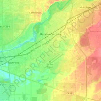
Nombre: Mapa topográfico Rancho Cordova, altitud, relieve.
Altitud media: 31 m
Altitud mínima: 4 m
Altitud máxima: 61 m
Otros mapas topográficos
Haga clic en un mapa para ver su topografía, su altitud y su relieve.