
Haz una donación
Mapa topográfico Muntinlupa
Haga clic en el mapa para ver la altitud.
Haz una donación
Muntinlupa
There are three plausible origins of the name of the city: First, is its association with the thin topsoil in the area; second, residents, purportedly replying to a question by Spaniards in the 16th century what the name of their place was, said “Monte sa Lupa”—apparently mistaking the question for what card game they were playing; third, the topographical nature of the area, where the term Monte or mountain was expanded to Muntinlupa or mountain land. Based on the 1987 Philippine constitution, it is spelled as Muntinglupa, instead of Muntinlupa.
Haz una donación
Acerca de este mapa
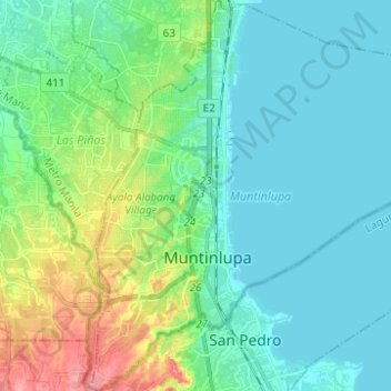
Nombre: Mapa topográfico Muntinlupa, altitud, relieve.
Lugar: Muntinlupa, Metro Manila, Philippines (14.34803 121.00495 14.46798 121.05730)
Altitud media: 22 m
Altitud mínima: 0 m
Altitud máxima: 92 m
Haz una donación
Otros mapas topográficos
Haga clic en un mapa para ver su topografía, su altitud y su relieve.
Haz una donación
Muntinlupa
There are three plausible origins of the name of the city: First, is its association with the thin topsoil in the area; second, residents, purportedly replying to a question by Spaniards in the 16th century what the name of their place was, said “Monte sa Lupa”—apparently mistaking the question for what…
Altitud media: 41 m