
Gracias por apoyar a este sitio ❤️
Haz una donación
Haz una donación
Mapa topográfico Krishnanagar
Haga clic en el mapa para ver la altitud.
Gracias por apoyar a este sitio ❤️
Haz una donación
Haz una donación
Krishnanagar
Krishnanagar is located at 23°24′N 88°30′E / 23.4°N 88.5°E / 23.4; 88.5. The area of the municipality is around 16 km2. It is situated on the southern banks of the Jalangi River. It has an average elevation of 14 metres (46 ft). The Tropic of Cancer passes through the outskirts of Krishnanagar. The latitude of the Tropic of Cancer is 23° 26′ 5″ N.
Gracias por apoyar a este sitio ❤️
Haz una donación
Haz una donación
Acerca de este mapa
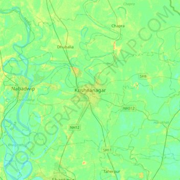
Nombre: Mapa topográfico Krishnanagar, altitud, relieve.
Lugar: Krishnanagar, Krishnagar-I, Nadia, West Bengal, 741101, India (23.24585 88.33589 23.56585 88.65589)
Altitud media: 11 m
Altitud mínima: 3 m
Altitud máxima: 29 m
Gracias por apoyar a este sitio ❤️
Haz una donación
Haz una donación