
Haz una donación
Mapa topográfico Balite I
Haga clic en el mapa para ver la altitud.
Haz una donación
Acerca de este mapa
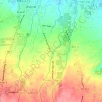
Nombre: Mapa topográfico Balite I, altitud, relieve.
Lugar: Balite I, Silang, Cavite, Calabarzon, 4118, Philippines (14.17955 120.96150 14.21955 121.00150)
Altitud media: 361 m
Altitud mínima: 310 m
Altitud máxima: 414 m
Haz una donación
Otros mapas topográficos
Haga clic en un mapa para ver su topografía, su altitud y su relieve.
Trece Martires
Philippines > Cavite > Trece Martires
The city of Trece Martires is characterised with ground elevation ranging from 30 metres (98 ft) to nearly 400 metres (1,300 ft). Its ground slope ranges from 0.5 to 2%.
Altitud media: 142 m
Cavite
Another theory proposes that the name is a Hispanicized form of kabit, Tagalog for "joined", "connected", or "attached", referring to the peninsula's topographical relation to the mainland. Edmund Roberts, in his 1821 memoir, stated that the "natives" called it Caveit due to the "crooked point of land…
Altitud media: 88 m
Haz una donación