
Mapa topográfico City of White Plains
Mapa interactivo
Haga clic en el mapa para ver la altitud.
Acerca de este mapa
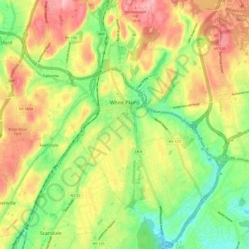
Nombre: Mapa topográfico City of White Plains, altitud, relieve.
Altitud media: 83 m
Altitud mínima: 16 m
Altitud máxima: 158 m
Otros mapas topográficos
Haga clic en un mapa para ver su topografía, su altitud y su relieve.
Shrub Oak
United States > New York > Westchester County > Town of Yorktown
Shrub Oak, Town of Yorktown, Westchester County, New York, 10588, United States
Altitud media: 156 m
Village of Ossining
United States > New York > Westchester County > Town of Ossining
Village of Ossining, Town of Ossining, Westchester County, New York, 10562, United States
Altitud media: 61 m
Lake Mohegan
United States > New York > Westchester County > Town of Yorktown
Lake Mohegan, Town of Yorktown, Westchester County, New York, 10547, United States
Altitud media: 140 m
Village of Pleasantville
United States > New York > Westchester County
Village of Pleasantville, Town of Mount Pleasant, Westchester County, New York, 10570, United States
Altitud media: 124 m