
Mapa topográfico Dalupiri Island
Mapa interactivo
Haga clic en el mapa para ver la altitud.
Acerca de este mapa
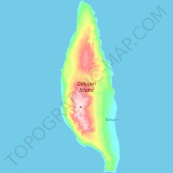
Nombre: Mapa topográfico Dalupiri Island, altitud, relieve.
Altitud media: 25 m
Altitud mínima: 0 m
Altitud máxima: 282 m
Dalupiri Island lies about 45 km (28 mi) north of Luzon and about 15 km (9.3 mi) north of Fuga Island. The island has an elongated elliptical shape orientated along a north–south axis, the island has a length of about 18 km (11 mi), with a width of about 7 km (4.3 mi) at its widest point. The topography of the island is characterized by a flat hilly landscape, in the center of the island, the terrain rises to 297 metres (974 ft) above sea level. The island has an area of 166 square kilometres (64 sq mi). The longest river of the island is the Manolong River, about 2.5 km long.
Otros mapas topográficos
Haga clic en un mapa para ver su topografía, su altitud y su relieve.
Babuyan Claro
Philippines > Cagayan > Calayan
Babuyan Claro, Calayan, Cagayan, Cagayan Valley, Philippines
Altitud media: 182 m