
Mapa topográfico The Lake Fleet Islands
Mapa interactivo
Haga clic en el mapa para ver la altitud.
Acerca de este mapa
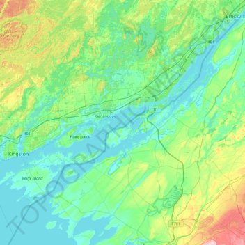
Nombre: Mapa topográfico The Lake Fleet Islands, altitud, relieve.
Altitud media: 108 m
Altitud mínima: 72 m
Altitud máxima: 267 m
Otros mapas topográficos
Haga clic en un mapa para ver su topografía, su altitud y su relieve.
Blue Mountain
Canada > Ontario > Leeds and Grenville Counties > Leeds and the Thousand Islands
Blue Mountain, Leeds and the Thousand Islands, Leeds and Grenville Counties, Eastern Ontario, Ontario, Canada
Altitud media: 124 m