
Mapa topográfico Lawrence
Mapa interactivo
Haga clic en el mapa para ver la altitud.
Acerca de este mapa
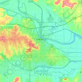
Nombre: Mapa topográfico Lawrence, altitud, relieve.
Lugar: Lawrence, Douglas County, Kansas, United States (38.90447 -95.34454 39.03350 -95.16662)
Altitud media: 265 m
Altitud mínima: 241 m
Altitud máxima: 333 m
Lawrence is located at coordinates 38.9716689, -95.2352501 in the state of Kansas,[4] approximately 25 miles (40 kilometers) east of Topeka, and 35 mi (56 km) west of Kansas City, Kansas. Though Lawrence has a designated elevation of 866 feet (264 m),[4] the highest elevation is Mount Oread on the University of Kansas campus with an elevation of 1,020 feet (310 m).[142][143]