
Mapa topográfico Unterrot
Mapa interactivo
Haga clic en el mapa para ver la altitud.
Acerca de este mapa
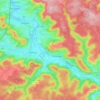
Nombre: Mapa topográfico Unterrot, altitud, relieve.
Altitud media: 416 m
Altitud mínima: 321 m
Altitud máxima: 517 m
Otros mapas topográficos
Haga clic en un mapa para ver su topografía, su altitud y su relieve.
Winzenweiler
Deutschland > Baden-Württemberg > Landkreis Schwäbisch Hall > Gaildorf
Winzenweiler, Eutendorf, Gaildorf, Verwaltungsverband Limpurger Land, Landkreis Schwäbisch Hall, Baden-Württemberg, 74405, Deutschland
Altitud media: 469 m