
Mapa topográfico Indang
Mapa interactivo
Haga clic en el mapa para ver la altitud.
Acerca de este mapa
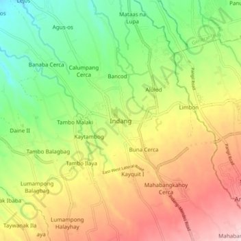
Nombre: Mapa topográfico Indang, altitud, relieve.
Lugar: Indang, Cavite, Calabarzon, 4122, Philippines (14.15583 120.83841 14.23583 120.91841)
Altitud media: 298 m
Altitud mínima: 150 m
Altitud máxima: 477 m
The topography of Indang is characterised by gently sloping or rolling terrain. Almost 40.36% of its total land area is within the slope grade of 3-8%, while 2,135 hectares is within the slope range of 8-15% which is characterised by undulating or sloping terrain.